Smarter solutions for better crop performance. We combine high-resolution spatial data with expert field surveys for a full analysis of your land and crop condition. Precision agriculture to solve food security issues.
Imagery and Mapping for Agriculture
We have mapped Indonesia and Malaysia’s agriculture extensively for nearly 20 years.
We have the expertise and flexibility to adjust to your needs and apply crop stress detection methods to any type of crop.
Crop Stress and Disease Detection
The most effective way to identify and control crop disease is to combine information from the ground (agronomists, producers) and the sky (drones, satellites, planes). We accurately identified Ganoderma boninense, or basal stem rot disease, in oil palm plantations using multispectral satellite imagery and ground-truthing. We can apply and tailor these methods to any crop type to identify disease. Speak to one of our experts to see how we can help you.
How it works
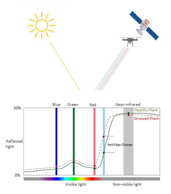
A specialized sensor is fitted to a drone or satellite that measures light reflectivity off the plant. Important crop health indicators are found within these light bands which can detect changes in crop health physiology and can be applied to identify stress and monitor crop health.
Step 1
Measure multispectral light reflectivity using remote sensing
Plant health can be accurately measured using light reflectivity in the visible and non-visible light spectrum. Red Edge and Near-Infrared light contain important plant health indictors and are highly sensitive to changes in crop physiology and stress, detecting early signs of disease invisible to the human eye. We can use this information to analyze crop performance.
Step 2
Data analysis – Generate vegetation indices and maps
Vegetation indices are algebraic combinations using light reflectivity to offer accurate measures of crop health. If used correctly, vegetation indices can be used for many applications including measuring chlorophyll content, stress, early signs of disease, invasive weeds, soil properties and identify areas in need of fertiliser applications. Many different types of maps can be produced using vegetation indices to look at different information, adapting to your crop and needs.
Ground Truth Data (GTD) and field surveys should also be used for more accurate analysis. Despite high accuracy and efficiency in remote sensing analysis, we need to verify and assess what is happening on the ground.
Ganoderma Identification
Vegetation indices can be generated to identify Ganoderma in oil palms. This is particularly useful for early detection in large-scale plantations where this method significantly reduces time and effort.
The below image shows a plantation experiencing severe outbreaks of Ganoderma. Multispectral imagery analysis was able to detect stressed palms, in the early to advanced stages. Field surveys and analysis confirmed Ganoderma.
Applications in crop health and management
Remote sensing informs better decision making in agriculture. It is a good indicator of where problems are located but doesn’t tell you the cause. Therefore, remote sensing guides scouting. After analysis, agronomists are then able to conduct targeted field surveys of those areas to find the root cause.
Research and Collaboration
EarthLine has links to universities and research facilities all over the world. We work together to provide cohesive reports drawing from experts at the top of their fields.

Banana Disease Research:
University of Exeter approached us for a project researching banana disease detection using multispectral imagery. A combination of farmer interviews, DNA sequencing and multispectral imagery using drone technology with used to effectively identify diseases and map disease spread. Three highly virulent diseases were found and the pattern of spread. This information was critical for farmers to understand pathogenic behavior and see where the diseases occurred and how to stop it. By identifying progress of disease occurrences and spread.
• Precision Agriculture Solutions
• Exploration, planning, development
• Crop stress detection and early warning systems
• Restoration and rewilding project services